
The seven-county Southeastern Wisconsin Region has a long history of aerial photography acquisition. Since 1963, the Southeastern Wisconsin Regional Planning Commission has obtained aerial photography as part of its regionwide planning activities. The black-and-white aerial photo inventories have been collected for the years 1963, 1967, and then at five-year intervals since 1970, ending in 2000. Since 1995, the aerial photography has been acquired in digital as well as hardcopy format.
For information regarding the 1963 through 2000 aerial photography in hardcopy format, see Aerial Photography and Orthophotography.
Recent aerial photography for the entire Southeastern Wisconsin Region was acquired by the Commission in the spring of 2015. Since 2005, all aerial photography has been obtained as color imagery. Beginning in 1995, all inventories have been collected as orthophotography, which is aerial photography enhanced by the removal of horizontal displacement caused by ground relief. Orthophotos are image products that can be used as true maps.
The Orthophoto Viewer is a mapping application that displays the year 2015 orthophotos for the Southeastern Wisconsin Region.
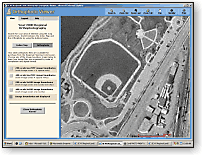
You can view an image of the entire region, or locate your neighborhood for an overhead view of your house and surroundings. Use the Index Map to locate and zoom to your area of interest, then choose the Orthophoto button to view the aerial orthophotography. You can switch between Orthophoto and Index Map to find other areas to view.
If you are interested in acquiring digital orthophotography, display the accompanying aerial photography image boundaries on the orthophoto to learn how the images are organized and the area that each image covers. You can also obtain the image file name to use to order
The 2015 digital orthophotography acquired for the Southeastern Wisconsin Region was collected in three project areas at three different pixel resolutions:
Orthophoto files for all project areas are available in two digital file formats:
Image files in the 6-inch project areas are organized to cover an area of 10,000 by 10,000 feet on the Wisconsin State Plane Coordinate System. Image files for the 3-inch project area (Kenosha County and Milwaukee County) cover an area of 5,000 by 5,000 feet on the Wisconsin State Plane Coordinate System.
The color GeoTIFF files described above merged into compressed files in MrSID format. Each image file in the 6-inch project areas covers one U.S. Public Land Survey System survey township (about 36 square miles). Each image file in the 3-inch project area (Kenosha County and Milwaukee County) generally covers one half of a survey township (about 18 square miles).
More detailed information about 2015 color digital orthophotography can be found in the description of 2015 digital products (PDF file) and the 2015 orthophotography metadata.
Digital orthophotos for the year 1995, 2000, 2005, 2007, and 2010 are also available for purchase from the Southeastern Wisconsin Regional Planning Commission. These images are available in GeoTIFF format and MrSID format files. The cost is $50 per CD-ROM or $100 per DVD plus tax and shipping (if applicable).
Digital orthophotography for 1995, 2000, 2005, 2007, and 2010 can be ordered by using the e-mail order form. Indicate that you would like to order orthophotography for any of these specific years in the "Additional Information" section at the bottom of the form. Or contact the Southeastern Wisconsin Regional Planning Commission if you would like to order 1995, 2000, 2005, or 2007 digital orthophotography.
Digital aerial orthophotos for the year 2015 (and previous years 1995, 2000, 2005, 2007, or 2010) are available for purchase from the Southeastern Wisconsin Regional Planning Commission. The digital orthophotos are delivered on CD-ROM or DVD. The cost is $50 per CD or $100 per DVD plus tax and shipping (if applicable). Please consult the 2015 description of digital products (PDF file) to learn how many image files can be placed on a CD or DVD and to determine how many disks may be required for all image files in your area of interest.
Use the e-mail order form to place an order for digital orthophotos. Please indicate the following information when ordering:
Orders for digital aerial orthophotos can usually be prepared within two to five working days after receipt of the order. CDs and DVDs will be shipped via U.S. Postal Service first class mail. If you would like to pick up the order at the offices of the Southeastern Wisconsin Regional Planning Commission, please so indicate on the order form.